Radar Simulators
Cloud Resolving Model Radar Simulator (CR-SIM)
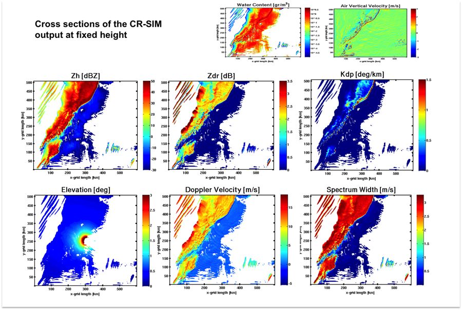
The idea behind CR-SIM is to create an accurate radar forward model operator consistent with several microphysics schemes that converts the model variables into the form of radar observations and thus to enable the direct comparison between numerical weather model output and radar observations. The CR-SIM can be applied in order to reproduce characteristic (polarimetric) signatures commonly found in (polarimetric) radar and lidar observations and examine the performance of different microphysical schemes and the assumptions related to scattering characteristics of observed cloud and precipitation systems.
|
EarthCARE Simulator (ECSIM)
The EarthCARE simulator provides end-to-end (forward and inversion) modeling of the instruments on board the European Space Agency EarthCARE mission. The instruments being considered for the EarthCARE platform are: An advanced lidar (ATLID), a Cloud pro_ling Radar (CPR), a Multi-spectral Imager (MSI) and Broad-Band Radiometer (BBR).
Data produced by a state-of-the-art, high-resolution cloud-resolving model (CRM) serve as the basis for creating `scenes' that will be used as input to various radiative transfer programs and instrument simulation modules. This provides the ability to simulate satellite overpasses and subsequent measurement processes. The simulator must be capable of performing end-to-end simulations of the EarthCARE mission.The simulator must be well-suited for synergetic observation studies. The simulator should be able to handle a range of cases from realistic complex cloudy scenes based on model data or more simple scenes which may be specified by the user.
|
User Guide: |
| ||
Radar Doppler spectra simulator
The radar Doppler spectra simulator is applicable to the MMCR, WACR and SACR’s systems of the ARM program and uses input from bin-microphysics, high resolution numerical models and produces synthetic radar Doppler spectra. The input parameters to a Doppler spectra simulator are both microphysical (e.g., particle size, shape, phase and number concentration) and dynamical (e.g., resolved wind components and sub- grid turbulent kinetic energy). The Signal-to-Noise Ratio (SNR) is used to determine the amount of noise added throughout the spectrum and the spectral smoothing due to spectral averages is included to reproduce the averaging realized by cloud radars on successive returns. Thus, realistic Doppler spectra are obtained, and several parameters that relate to the morphological characteristics of the synthetically generated spectra are computed using the same algorithm used by ARM to develop the micro-ARSCL VAP.
Download the software
Satellite Radar Simulator (SR-SIM)
SR-SIM is a Fortran 90 package that computes synthetic satellite radar observations using output data from the high resolution Weather Research and Forecasting Model (WRF) and Global Environmental Multi-scale Model (GEM).
SR-SIM simulates radar reflectivity and attenuation consistently with the specifications of the spaceborne radar and the model microphysics parametrization.
In the current version, SR-SIM is using Milbrant-Yau double-moment bulk microphysics scheme and the specifications of the GPM Dual-frequency Precipitation Radar (DPR), consisting of a Ku-band and Ka-band radars with frequencies 13.6 GHz and 35.5 GHz respectively.
The structure of the project was conceived to easily incorporate new code, allowing the ingestion of new input model or satellite files, other particle size distribution (PSD) settings, etc.
Download the software
|
User Guide: Scientific documentation:
|
| ||||