Research
The “cloud problem”, i.e., the understanding of the microphysical, dynamical and radiative processes that act at the cloud scale and their accurate representation in numerical models is the central theme of our research. Synergetic remote sensing observations from both space-based and ground-based sensors and their clever use through the development of new inversion algorithms and adaptive sampling strategies constitute our approach for probing clouds and precipitation in their natural environment. As part of our research we use a wide variety of observational platforms, however, millimeter wavelength radars are our primary observing tool for diagnosing the structure, kinematics and microphysics of clouds and precipitation.
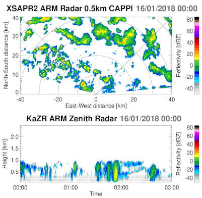
Top: Gridded, constant altitude plan position indicator, CAPPI, animation of the X-band Scanning ARM Precipitation Radar (XSAPR2) on 01/19/2018 at Graciosa Island, the Azores. Bottom: corresponding time-height plot of the Ka-band ARM Zenith-pointing Radar (KAZR) for the same day. For more information see Lamer et al., 2019
Current research projects
Investigation of Microphysics and Precipitation for Atlantic Coast-Threatening Snowstorms (IMPACTS)
Agency: NASA
Winter snowstorms are frequent on the eastern seaboard and cause major disruptions to transportation, commerce, and public safety. Snowfall within these storms is frequently organized in banded structures that are poorly understood by scientists and poorly predicted by current numerical models. Since that last study on snowstorms, the capabilities of remote sensing technologies and numerical weather prediction models have advanced significantly, making now an ideal time to conduct a well-equipped study to identify key processes and improve remote sensing and forecasting of snowfall. Read more...
Winter snowstorms are frequent on the eastern seaboard and cause major disruptions to transportation, commerce, and public safety. Snowfall within these storms is frequently organized in banded structures that are poorly understood by scientists and poorly predicted by current numerical models. Since that last study on snowstorms, the capabilities of remote sensing technologies and numerical weather prediction models have advanced significantly, making now an ideal time to conduct a well-equipped study to identify key processes and improve remote sensing and forecasting of snowfall. Read more...
Experiment of Sea Breeze Convection, Aerosols, Precipitation and Environment (ESCAPE)
Agency: NSF
The National Science Foundation recently supported a large field experiment entitled: “Experiment of Sea Breeze Convection, Aerosols, Precipitation and Environment (ESCAPE)”. The overarching scientific objective of ESCAPE is to collect and analyze observations of the fundamental process-level coupling between convective cloud vertical motions (kinematics), microphysics, and precipitation production across a full range of cloud environments (including background aerosol conditions) and meteorological regimes, throughout their lifecycle. ESCAPE is scheduled to take place in the Houston area, TX from June 10 to July 25, 2021. The observational platforms involved in the ESCAPE field campaign include two aircrafts, the NCAR C-130 and the SPEC Learjet, three mobile X-band radars, one mobile Doppler lidar truck and one transportable C-band radar. Read more...
The National Science Foundation recently supported a large field experiment entitled: “Experiment of Sea Breeze Convection, Aerosols, Precipitation and Environment (ESCAPE)”. The overarching scientific objective of ESCAPE is to collect and analyze observations of the fundamental process-level coupling between convective cloud vertical motions (kinematics), microphysics, and precipitation production across a full range of cloud environments (including background aerosol conditions) and meteorological regimes, throughout their lifecycle. ESCAPE is scheduled to take place in the Houston area, TX from June 10 to July 25, 2021. The observational platforms involved in the ESCAPE field campaign include two aircrafts, the NCAR C-130 and the SPEC Learjet, three mobile X-band radars, one mobile Doppler lidar truck and one transportable C-band radar. Read more...
Collaborative proposal: Studies of the microphysical processes in
ice and mixed-phase clouds and precipitation using multi-parameter
radar observations combined with cloud modelling
Agency: NSF
A better understanding of the microphysics in winter storms, including dendritic growth, riming, and aggregation aloft and processes in the melting layer will contribute to improved bulk microphysics parameterizations used in operational numerical weather prediction models. This, in turn, will lead to better quantitative precipitation forecasts and forecasts of winter weather hazards.
This funded effort offers a comprehensive, in-depth analysis of the microphysics of cold-season storms utilizing a unique combination of the most sophisticated, state-of-the-art tools in modern weather radar technology and explicit microphysical modeling. In particular, the project capitalizes on a unique synergy of polarimetric, multi-frequency, and Doppler spectral measurements with the data presented in a standard height vs time format to grasp the vertical structure of the storm and its temporal evolution.
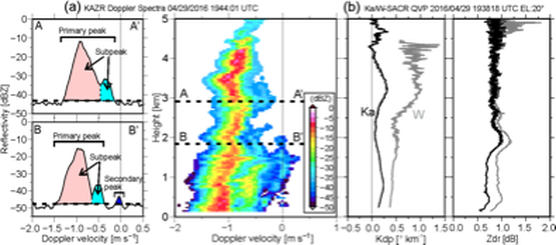
Fig. (a) Example of KAZR Doppler velocity spectra showing profile and single spectra along A-A’ and B-B’. Color shade in the profile plot represents reflectivity. (b) QVPs of ZDR and KDP estimated from a PPI scan at an elevation angle of 20°. Adapted from Oue et al. (2018).
Aerosols and Cloud-Convection Precipitation (A-CCP) Study
Agency: NASA
The goal of the Aerosols, Clouds, Convection and Precipitation study is to define objectives for the A and CCP Designated Observable (DO) observing systems, the desired capabilities associated with these observables, and observing systems approaches to achieve them. This study leverages the results from studies such as the Aerosol-Cloud-Ecosystems (ACE) study, those from existing and proposed Earth Venture concepts, and analysis already conducted on data from past field experiments and recent advances of modeling systems and Observing System Simulation Experiments (OSSEs).
Kollias is a member of the Science Impact Team (SIT) that is charged to evaluate the extent to which various measurements architectures (i.e. sets of measurables with specified characteristics) provide the geophysical parameters required to meet the science objectives and contribute to application objectives. The SIT inputs will help the A-CCP team quantifiably measure the information or constraints that measurement architectures provide for specific science questions or geophysical parameters. The SIT inputs will assist in the A-CCP team's measurement of the contribution that a particular observing system configuration provides to a science question, either via the geophysical parameters required to address it, or more indirectly when these observables are assimilated in earth system models. Read more…

Earth’s Cloud, Aerosol and Radiation Explorer (EarthCARE) mission
Agency: European Space Agency
The Earth Clouds, Aerosols and Radiation Explorer (EarthCARE) satellite is a joint European Space Agency and Japanese Aerospace Exploration Agency mission scheduled to launch in 2023. EarthCARE (EC) will host the first Doppler cloud profiling radar (CPR) in space which, in addition to constraining microphysical retrievals in particle sedimentation regimes, is expected to provide the first ever global observations of convective vertical air motion and associated mass fluxes. The radar science group is responsible for the development of the L2A CPR-only algorithm for the retrieval of cloud and precipitation macrophysical, microphysical and dynamical properties. Read more…
The Earth Clouds, Aerosols and Radiation Explorer (EarthCARE) satellite is a joint European Space Agency and Japanese Aerospace Exploration Agency mission scheduled to launch in 2023. EarthCARE (EC) will host the first Doppler cloud profiling radar (CPR) in space which, in addition to constraining microphysical retrievals in particle sedimentation regimes, is expected to provide the first ever global observations of convective vertical air motion and associated mass fluxes. The radar science group is responsible for the development of the L2A CPR-only algorithm for the retrieval of cloud and precipitation macrophysical, microphysical and dynamical properties. Read more…

Artist’s view of EarthCARE. Adapted from http://www.esa.int/Applications/Observing_the_Earth/The_Living_Planet_Programme/Earth_Explorers/EarthCARE/ESA_s_cloud_aerosol_and_radiation_mission
Weather Applications of Low-power X-band Phased Array Radars (SKYLER)
Agency: Raytheon
Stony Brook University and Raytheon have entered an agreement to work on weather applications for their low-power X-band Phased Array Radar (SKYLER). A SKYLER system has been made available to SBU and has been used to evaluate its performance in a variety of weather conditions.
Stony Brook University and Raytheon have entered an agreement to work on weather applications for their low-power X-band Phased Array Radar (SKYLER). A SKYLER system has been made available to SBU and has been used to evaluate its performance in a variety of weather conditions.
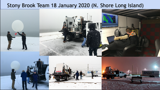
Example of radar Doppler velocity measurements with a low-level jet during a winter storm
observed at the north shore of Long Island, NY.
observed at the north shore of Long Island, NY.